Showing posts with label charles dickens. Show all posts

Monday, August 15, 2016

Charles Dickens and the Siegfried Tavern

A mile or two north of Delaware, Ohio, stands a weatherbeaten frame building, vacant since 1985, and bearing the usual marks of protracted habitation — additions, alterations, and augmented apertures. It faces busy US Highway 23, which approximates the route of an early road connecting Columbus and Sandusky. The structure's situation betrays its purpose; it served as a tavern (or inn), operated by Jacob Siegfried (1788–1846), a Pennsylvanian, between 1835 and — I presume — 1846.

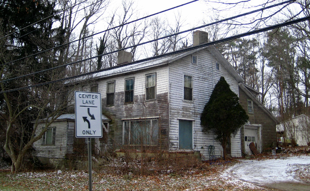
Siegfried's tavern in 2008. (Yes, this photo is terrible; but then, a person trapped in a moving vehicle cannot expect compositional brilliance!)

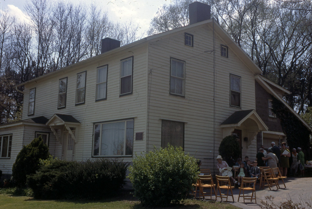
And, Siegfried's tavern before its abandonment. Photo by George Cryder (?), 1969, from the Delaware County Historical Society collection.

Affixed to the building is a metal plaque, rendered unreadable (during summer months, at least) by unkempt bushes. In my many years of passing the tavern, I could decipher only one word — "tavern" itself. Imagine my surprise, then, when I browsed the Delaware County Historical Society's slide collection and found this:

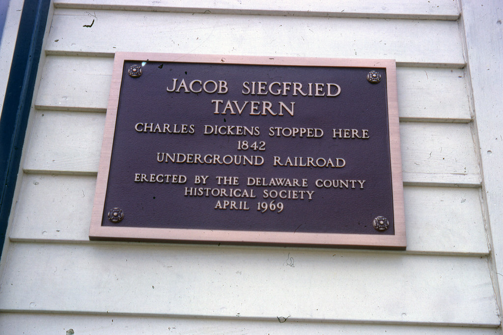
The plaque. Image by George Cryder (?), 1969, from the Delaware County Historical Society collection.

At first, I accepted the claim with delight. I'd long known about Dickens's 1842 excursion to America, recounted, with invaluable cynicism (1), in American Notes for General Circulation. But, after a moment's thought, I felt a twinge of uncertainty. Though I'd read (and reread) the portion of American Notes covering the Ohio leg of Dickens's journey, I could recall no mention of Delaware.

In the fourteenth chapter, Dickens describes his sole jaunt through Ohio's interior (2):
There being no stage-coach next day, upon the road we wished to take, I hired 'an extra,' at a reasonable charge to carry us [from Columbus] to Tiffin; a small town from whence there is a railroad to Sandusky. This extra was an ordinary four-horse stage-coach, such as I have described, changing horses and drivers, as the stage-coach would, but was exclusively our own for the journey. To ensure our having horses at the proper stations, and being incommoded by no strangers, the proprietors sent an agent on the box, who was to accompany us the whole way through; and thus attended, and bearing with us, besides, a hamper full of savoury cold meats, and fruit, and wine, we started off again in high spirits, at half-past six o’clock next morning, very much delighted to be by ourselves, and disposed to enjoy even the roughest journey. 
We alighted in a pleasant wood towards the middle of the day, dined on a fallen tree, and leaving our best fragments with a cottager, and our worst with the pigs . . . we went forward again, gaily. (3)
As I feared, not so much as a mention of inns, taverns, or Delaware. (I doubt even Dickens, contemptuous of America though he was, would dare to call Siegfried a "cottager.") In the following pages, Dickens describes only one stop between Columbus and Tiffin — Upper Sandusky, which lies well north of Delaware. If Dickens hired an "extra" for the sake of "being incommoded by no strangers," and dined (while sitting on a fallen tree) from his coach's supply of "savoury cold meats, and fruit, and wine," why would he stop at Siegfried's tavern? Why inconvenience himself with the company of strangers? And why avoid writing about the sojourn?

Dickens's diary provides few answers (though, unlike American Notes, it does mention that his coach changed horses several times). A folder labeled "Siegfried Tavern" — held by the Delaware County Historical Society — contains property research and biographical information about the Siegfried family, but barely mentions Dickens's supposed stay. The 1842 copies of Delaware newspapers seem to be lost.

The plaque's claim, then, is neither provable nor falsifiable. The weight of evidence may lie on the side of doubt, but mere weight is scarcely proof. I've no choice but to speculate.

Perhaps the story is merely hearsay — a local legend repeated by innumerable Herodotuses, and having no more credibility than the 6.2 x 10^14 similar tales about George Washington, Andrew Jackson, and Abraham Lincoln. Perhaps "Dickens passed this tavern" mutated, as verbal accounts are wont to do, into "Dickens stopped here." Or, perhaps, Dickens gave a hearty wave from his coach; Siegfried noticed and passed the impression to his descendants, in whom it transformed into today's story. Or Dickens indeed paused at Siegfried's tavern, albeit briefly, and simply for a change of horses or a bit of leg-stretching.

1) The best nineteenth-century descriptions of America tend to be those given by foreigners.
2) Though Dickens twice visited Cincinnati, he ventured into the state proper only once.
3) American Notes for General Circulation, Volume II (1842), 133–134.

Tuesday, May 24, 2016

Ohio's Roads

Ohio's earliest rural inhabitants, with a few exceptions, practiced subsistence agriculture, and thus needed no refined road network. Scattered trails, passable by foot, horse, or ox-cart, sufficed. These rudimentary roads — exemplified, perhaps, by Zane's Trace — often supplanted Native American byways or deer trails and followed irregular paths. Others; blazed by the U.S. military, established by state decree, or formed by private companies as toll roads; proceeded linearly. In the Congress Lands, thoroughfares often (though not invariably) follow section lines. In the Virginia Military District, the routes seem, in some cases, truly arbitrary. (See, for instance, Greene County's serpentine State Route 72.)

By mid-century, Ohio's counties — or, at least, its well-populated counties — had largely acquired the ample road systems which survive today. (The frequency with which Greek Revival-era dwellings — even those fronting minor thoroughfares — align with roads is evidence of this.)

Inter-County Highway 124 (now State Route 28), a superlative dirt road. Photo from the ODOT archives. The background home is extant.

Until the twentieth century, the Ohio traveler could expect little in the way of comfort. Indeed, a few wealthier counties had, in the preceding century, gravelled or macadamized their roads, but the balance of the state's routes were, by all accounts, veritable styes. In American Notes, Charles Dickens (yes, that Charles Dickens) quips about an 1842 stagecoach ride from Columbus to Sandusky:
It was well for us, that we were in this humour, for the road we went over that day, was certainly enough to have shaken tempers that were not resolutely at Set Fair, down to some inches below Stormy. At one time we were all flung together in a heap at the bottom of the coach, and at another we were crushing our heads against the roof. Now, one side was down deep in the mire, and we were holding on to the other. Now, the coach was lying on the tails of the two wheelers; and now it was rearing up in the air, in a frantic state, with all four horses standing on the top of an insurmountable eminence, looking coolly back at it . . . (1)
Earth-surfaced (i.e., dirt) roads in Ohio, 1915. Data sourced from Names and Numbers of Inter-County Highways and Main Market Routes, and Highway Statistics of Each County, published by the Ohio Highway Department. The darker the county's coloring, the greater its percentage of dirt roads. (Belmont County is clearly an anomaly.)

Navigational Nomenclature

In the nineteenth and early twentieth centuries, the state's county- and township-maintained routes lacked formal names. Open any Victorian-era property atlas, or glance at any prewar county highway map: the local roads are bound to be anonymous. Only after World War II, I suspect, did township and county governments bother to name their vast road networks. (More than likely, this mass-christening coincided with the widespread paving of minor thoroughfares, which had hitherto been largely earth-surfaced.)

A (rather crude) typology of Ohio road name etymologies. The colors designate each county's predominant method of thoroughfare-labeling. A few eastern Ohio counties assign names to only major roads; hence, in Perry County, Wilson Road (County Road 35) intersects Township Road 46, and so on.

Many of Ohio's rural roads bear "connective" names designating the communities which lie at their termini, or else describe the property owners whose tracts sat at their ends. Rosedale-Plain City Road, in northern Madison County, joins unincorporated Rosedale and more metropolitan Plain City, naturally. To the south, Pancake-Selsor Road honors members of the Pancake and Selsor families, prominent in southern Madison County. Rarely do given names appear in road labels. Adams County contains a few exceptions: Starley Gustin Road (which traverses fertile bottomland bordering Ohio Brush Creek), Ira Gustin Road (in Bratton Township), and George C. Biely Road, among others. Many more road names are sourced from natural features, as the repetition of "Hollow," "Valley," and "Run" — in Ohio's Appalachian counties — attests.

All Ohio counties assign numbers to their thoroughfares, but a few (clustered mostly in the state's northwestern quadrant) lack true, or nominal, titles. Williams County, bordering Indiana and Michigan, uses a hybrid numeric-alphabetic system, with its north-to-south-running routes receiving a number (1 through 24), and its east-to-west-traveling roads receiving a letter (A through S). The many routes that deviate by splitting sections combine letters and numbers. Thus, near Montpelier is County Road K-50 (a longitudinal byway situated equidistant from County Road K and County Road L). Logan County's numbering, on the other hand, appears to be inexplicable.

Carroll County's traffic engineers seemingly selected its roads' names by flinging darts at a board or, perhaps, choosing dictionary entries at random. Bacon Road begins at Arrow Road; intersects Glacier, Glory, Jasmine, Buck, Gallo, Fisherman, and Trump; and terminates at a state highway. Elsewhere, Aurora meets Apollo, and Nassau encounters Nature. Confusingly, Lemon Road lies a few miles distant from Lumen Road. Andora Road commemorates — in misspelled form — the tiny Pyrenean nation of Andorra (or Andora, Italy), while Ming Road may memorialize the long-lived Chinese dynasty.

Other oddities surely exist, scattered across Ohio's 44,825 square miles.

1) American Notes for General Circulation, Volume II (1842), 162.