Wednesday, July 19, 2017

The Albert J. Ewing Collection: Glimpses of a Long-Lost Landscape

Cross-posted from the Ohio History Connection's blog.

In 2017, it's not difficult to document the world. Storage space is cheap, and opportunity cost is practically nonexistent. Cameras and computers allow geographers and architectural historians — amateur and professional alike — to capture, store, and edit a thousand images of whatever strikes their fancy. Thanks to Google and Bing, a person needn't visit a place to understand its atmosphere, to sample its je ne sais quoi.

But finding visual documentation from before the era of abundant information remains an ordeal. Everyone who owns a historic home dreams of discovering some glorious daguerreotype showing the structure as built, but few succeed. In the nineteenth century, portrait photography outshone landscape photography. Then, as now, people tended to overlook the ordinary. In far-flung places — rural Appalachia, for instance — the problem was particularly acute. The Ohio History Connection, though, holds one collection unmatched in its ability to give a glimpse of the turn-of-the-century landscape: a store of more than 5,000 plate-glass negatives, gloriously detailed, captured by the wandering photographer Albert Ewing.

Albert J. Ewing (1870–1934) spent his early years near Marietta, the first permanent settlement within the Northwest Territory, founded by the Massachusetts-based Ohio Company of Associates in 1788. The fertile valleys of the Ohio River and Muskingum River attracted plenty of early settlement, but the rugged, stream-dissected Allegheny Plateau remained sparsely populated until the nineteenth century’s closing decades. For the most part, the land of southeastern Ohio and central-western West Virginia allowed only subsistence agriculture. Homesteaders lived in relative squalor and farmed sloping plots within isolated mountain hollows. But turn-of-the-century oil exploration brought prosperity to the region and, in turn, triggered a building boom. It is this landscape — a landscape newly transformed by mineral wealth, dotted with derricks and oddly exuberant dwellings — that Ewing’s images allow us to glimpse in unparalleled detail.

http://www.ohiomemory.org/cdm/singleitem/collection/p16007coll19/id/797/rec/149
A newly constructed farmhouse of standard turn-of-the-century appearance. Location unknown. Despite its hilliness, the land surrounding the house is largely cleared for agriculture; today, the same spot is probably densely forested.

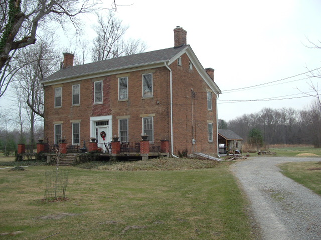
Some of the houses in Ewing’s photos seem strikingly new — coated with unblemished paint, constructed of unweathered wood, and adorned with unbroken scrollwork, spandrels, and medallions. This is hardly surprising. Many of them are (or were) new. They tend to display the hallmarks of turn-of-the-century domestic architecture: an affinity for traditional forms, liberal use of lathe-turned woodwork, and a repetition of certain types of ornamentation. Ewing’s camera even captured some buildings during construction, and one pair of plates depicts the same home before and after a renovation.

http://www.ohiomemory.org/cdm/singleitem/collection/p16007coll19/id/611/rec/593
A plain farmhouse of "saltbox" form — likely a frame building, but possibly log. Location unknown.
http://www.ohiomemory.org/cdm/singleitem/collection/p16007coll19/id/686/rec/582
The same house — a decade or two later, and after a reroofing and the addition of a two-story porch.

Other photos show the poverty for which Appalachia is (rightly or wrongly) famous. Ewing's images of log buildings, in particular, are among his collection's most valuable. One — labeled "rural life," perhaps ironically — depicts a small log house and its accompanying log outbuilding. The outbuildings's roof is supported by purlins — a construction method common to Ohio's earliest cabins. (Yes, there is a difference between a log cabin and a log house, but that's a subject for another post.) In another image, the log house stands, encircled by a picket fence, among unkempt-looking fields. Additions obscure two of the log pen's four sides, the roof is clad with wood shingles, and the house's plates overhang the walls. Had Ewing jumped into H.G. Wells's time machine and emerged in the year 1830, he might still have returned with (almost) identical-looking images.

http://www.ohiomemory.org/cdm/singleitem/collection/p16007coll19/id/1124/rec/2
http://www.ohiomemory.org/cdm/singleitem/collection/p16007coll19/id/663/rec/166


Still other photos depict buildings within a broader context. In one, the farm complex, rimmed by sloping pastureland and split-rail fences, straddles a small stream; in the other, the house and outbuildings stand on a level upland. One farmhouse is rather crudely constructed and sided with boards and battens (and, thus, might be a remodeled log building); the other, a balloon-frame structure of "I" form, was likely built within a few years of Ewing's visit. (The second-floor entries suggest that the owner planned to grace his abode with a two-story porch.) In both cases, the homes' chimneys send forth puffs of smoke — not surprising, for Ewing captured a great many of his images in the autumn, winter, and early spring.

The two photos, like all within the collection, are deliciously detailed, and they permit the curious to see the long-dead accoutrements of Appalachian agricultural life: carts, carriages, millstones, chickens, cattle, orchards, dirt lanes, split-rail fences, and sloping fields — and, of course, the owners themselves, often proudly standing by those marks of civilization they helped wrench from nature.

http://www.ohiomemory.org/cdm/singleitem/collection/p16007coll19/id/818/rec/165
http://www.ohiomemory.org/cdm/singleitem/collection/p16007coll19/id/639/rec/166

But enough rambling. 1,435 of Ewing's 5,055 negatives are available, in 5,000-by-4,000-pixel glory, via Ohio Memory. As the old saw says, a picture is worth a thousand words. Do take a look!

Friday, July 14, 2017

Brick Columns in Warren County

It's not difficult to spot similarities between, say, the boxy braced-frame (and log) farmhouses of Wayne County and dwellings in southeastern Pennsylvania's Amish heartland, but finding direct connections between Ohio buildings and their East-Coast antecedents is a more arduous task. Still, some have managed it. Frary traces floral woodwork in one Western Reserve farmhouse to a home in rural Maine, and Asher Benjamin's designs are duplicated in countless structures — residential, commercial, and public alike. I suspect that most comparisons between individual buildings are, in all likelihood, mistaken, but the temptation remains.

In suburbanizing Hamilton Township, Warren County (one of Ohio's finest counties, if I may say so), are two Federal-era residences with peculiar similarities to at least one Virginia plantation home. One stands on Schlottman Road, just north of the township's southern boundary and a stone's throw from Benjamin Butterworth's hillside farmhouse (1815); the other sits on a sloping, stream-side lot, south of Maineville (a community founded, as its name suggests, by ex-citizens of New England's northeasternmost state).

The Schlottman Road house was owned, during the nineteenth century's second quarter, by members of the Hill family, but its exact history is murky. The building's facade is standard transitional Federal–Grecian fare — five bays in width, with a narrow frieze board, trabeated doorway, and rectangular stone lintels and sills. What lies behind the facade is a bit odder. Unlike most "I" houses (dwellings multiple rooms in width, but only one in depth), the Hill House features an additional row of rooms, which allow for extra fireplaces and a two-story inset porch (now enclosed), and which lend the house a "saltbox" roofline.

The Hill House (WAR-631-11), supposedly constructed in 1817; expanded circa 1845. Photo from the Warren County Auditor's website.

At the home's rear, though, is its truly intriguing feature. Extending from the two-story section is a one-and-a-half-story wing (not an oddity in itself), constructed of Flemish-bond brick. According to local lore, this wing predates the "I" portion by several decades — a claim I'm more than willing to believe. A two-bay section of this wing is recessed, and the resulting porch is supported by polygonal brick columns with blocky capitals and plinths. Clunky though they may be, these columns are distinctive. Ohio has a plethora of recessed porches, but few — if any — use brick as a supporting material (though I know of two arcaded porches in Lawrence County).

The home's rear (more interesting, I think, than its facade). The 1817 section lies to the right. Note the fieldstone springhouse. Photo from the Warren County Auditor's website.

Campbell County, Virginia's Green Hill Plantation, built about 1800, features a similar porch. As might be expected, Green Hill's columns are more sensitively handled; they're round, rather than polygonal, and they're topped with more typologically accurate capitals and plinths. Unfortunately, some of the many outbuildings and dependencies which once encircled Green Hill have disappeared, but the house remains, thank goodness.

Porch, Green Hill (circa 1800); Long Island vicinity, Campbell County, Virginia. Photo from the Historic American Buildings Survey collection. Photographer and date unknown.

A few miles northeast of the Hill House; in Warren County, Ohio; stands a second dwelling — this one omitted from the Ohio History Inventory — with a brick-columned porch. In this case, the porch is two stories in height, and, instead of being tucked into a rear wing, it boldly graces the facade. The columns are circular (rather than polygonal), but their capitals are no more elegant than the Hill House's. An 1875 property atlas lists a J.E. Murdock as the farm's owner. Murdock's family lent its name to a crossroads community just south of the residence.

Murdock House; circa 1835 (?). Photo from the Warren County Auditor's website.

Sunday, July 2, 2017

The Residences of Rural Sandusky County, Ohio

Last week, I finished my survey of rural Sandusky County, Ohio. Rather than merely silently posting a link to the Fusion Table on the usual page, I'll also write about what I've discovered. For those who care not to read, here's the map:


A Slapdash History

In 1820, Sandusky County was carved — along with a dozen other northwestern-Ohio counties — from ex-Shawnee territory confiscated by the Treaty of Fort Meigs (1817). At the time, a mere 852 souls called the county home. The area remained sparsely populated until two waves of migration — the first in the 1830s, the second between 1850 and 1860 — sent settlers into its lands. The earliest settlement occurred along certain streams: the Sandusky River (which bisects the county), the Portage River, and other, smaller waterways. Modern-day US Highway 20, an early road connecting Perrysburg and the Western Reserve, also functioned as an artery of settlement. Like most northwestern-Ohio counties, Sandusky encompassed much waterlogged land, and its landscape reached a stable state of development only during the nineteenth century's closing decades. The second migration wave contained a great many Germans — from a variety of principalities, including Baden and Bavaria — as well as a slew of Swiss.

Fremont (no, not Sandusky), once a frontier outpost adjoining Fort Stephenson, has always served as the county seat. Before and after the county's formation, the city was (rather confusingly) known as Lower Sandusky, no doubt because of its location near the Sandusky River's mouth. In 1849, the village's residents chose to rechristen their home in honor of John C. Frémont (1813–1890), then known as an explorer and military man (and not the Republican Party's first candidate). The first Sandusky County courthouse — perhaps Ohio's only log civic building for which plans survive — served between 1826 and 1843. In 1844, a Greek Revival edifice replaced the log structure.

Sandusky County's current courthouse — built in 1844, and expanded, with unusual sensitivity, in 1936.

Survey Results

During my survey, I discovered 273 rural homes worthy of note — a higher number than I'd expected, though not terribly surprising, given Sandusky County's predominantly Germanic settlement geography.* A fair number of buildings are already included in the Ohio Historic Inventory and National Register, mostly because of a 1984 survey conducted by Andrew Gulliford. Still, the OHI and NRHP include only 63 homes, about 23 percent of my total. The overwhelming majority of rural Sandusky County's buildings (perhaps 80 percent) postdate the Civil War. As always, my survey favors brick structures, which — thanks, again, to the county's Germanitas — exist in abundance. Many rural homes adhere to familiar formulas; the terms "upright-and-wing" and "gabled ell" appear, by the dozens, in my table. The Italianate style, too, was popular among nineteenth-century Sanduskyites. This isn't surprising. The county's greatest period of development happened to coincide with the style's peak in national popularity (outside the cities, between 1865 and 1885).

I can (crudely) divide Sandusky County into three architectural regions. The first comprises the easternmost townships — Townsend and York, as well as portions of Riley and Green Creek; the second stretches, in an "L" shape, from the county's center to its northwestern corner, near Woodville; the last covers the southwestern quadrant.

The East

In Townsend and York townships, Yankee, Pennsylvanian, and Germanic architectural traditions collided in interesting ways. This region, populated by the aforementioned 1830s wave, contained many of Sandusky County's wealthiest and oldest farms. (It was also the least swampy.) Remodeled braced-frame buildings, some with frieze windows and vestigial Greek Revival flourishes, are scattered, willy-nilly, across the area's farms. A few limestone houses stand near the Huron County–Erie County border, due south and north of Bellevue. In eastern Sandusky County, the so-called "upright-and-wing" house-type — so popular in the Western Reserve — is a common sight. A number of "upright-and-wing" homes in York Township display Gothic Revival quirks: gabled wall-dormers, lancet-arched windows, scrollwork, and bargeboards.

Smith House, York Township. 6710 Billman Road. Note the "upright-and-wing" form, wall dormers, and lancet-arched windows. Photo from the Sandusky County Auditor's website.

Deyo House (SAN-448-12), York Township. 2895 Flat Rock Road. One of the county's few stone buildings. Photo from the Sandusky County Auditor's website.

Winters House, Townsend Township. 6201 US Highway 6. A Gothic–Grecian fusion par excellence. Photo from the Sandusky County Auditor's website.

Perhaps eastern Sandusky County's most interesting dwellings are those which use an odd form of brickwork called, variously, "double Flemish bond" and "monk bond." Oddly enough, this method of construction seemed to be popular among New Englanders and Germans in the vicinity of Bellevue; examples exist in Erie, Huron, Sandusky, and Seneca counties. The homes are too numerous to be the products of a single builder.

Sparks House, York Township. 5821 State Route 101. The brickwork is exceptional. Photo from the Sandusky County Auditor's website.

The Middle (and Northwest)

Sandusky County's vast midsection — the lands bordering the Sandusky River; much of Ballville, Sandusky, Rice, and Riley townships — received the majority of its German settlers. Others purchased tracts in the county's northwestern quadrant, in Woodville and Washington townships. The area's dwellings vary in age, pretension, and appearance. Brick "gabled ell" farmhouses, often unadorned (sans the ubiquitous segmental arches), are commonplace. The region's Italianate homes tend to feature severely truncated hip roofs (almost, but not quite, mansard) and intricately carved stone window hoods. Half-circle- and quarter-circle-shaped attic vents and windows are also oddly common.

Weber House, Sandusky Township. 3323 Werth Road. A well-preserved, unabashedly Germanic farmhouse. Image from the Sandusky County Auditor's website.
King House, Rice Township. 680 Overmyer Road. Image from the Sandusky County Auditor's website.
Batzine House, Rice Township. 331 Woodrich Road. A plain "gabled ell" with segmental-arched windows and a tall foundation. Photo from the Sandusky County Auditor's website.
Hetrick House, Rice Township. 2959 Four Mile House Road. Similar to 331 Woodrich Road, but with quarter-circle (or half-lunette) attic windows. Photo from the Sandusky County Auditor's website.
Philip Overmyer House (1862), Washington Township. 654 State Route 590. Luckily, this splendid home is NRHP-listed. Photo from the Sandusky County Auditor's website.

In Washington Township, just south of Elmore, stand two nearby identical brick cottages, undistinguished except for a pair of peculiar elliptical windows squeezed above the porch roof.

Burgman House, Washington Township. 3910 Swartzman Road. Photo from the Sandusky County Auditor's website.

Mellman House, Washington Township. 3806 Damschroder Road. Image from the Sandusky County Auditor's website.

A few Queen Anne houses; constructed for wealthy, non-German landowners; stand on the banks of the Sandusky River, south of Fremont.

Ballville Township. 4319 Darr Road. Photo from the Sandusky County Auditor's website.

One of Sandusky County's few extant log buildings stands in Rice Township.

Zitles House (?), Rice Township. 3184 Weickert Road. Removal of the porch has exposed the logs. The central chimney is a Germanic trait. Photo from the Sandusky County Auditor's website.

The Southwest

The lands lying south of the old Maumee and Western Reserve Road (US Highway 20) and west of the Sandusky River; near Gibsonburg, Helena, and Burgoon; harbor Sandusky County's least-pretentious buildings. Here, the architectural landscape is defined by remodeling, demolition, and abandonment. The limestone barrens running between Woodville and Fremont (part of the larger "Oak Openings" microregion) are unsuitable for agriculture, and portions of Madison, Scott, and Jackson townships remained ill-drained until the late nineteenth century, when ditching and tiling efforts opened the area to settlement. Frame farmhouses, many of "gabled ell" form, predominate, though plenty of brick structures exist here, too.

Fairbanks House, Madison Township. 4810 US Highway 6. The quintessential Sandusky County farmhouse. Photo from the Sandusky County Auditor's website.
Scott Township. 5910 Girton Road. Another "gabled ell" dwelling — this one clad in brick veneer, with a bit of gable ornamentation. The house dates from the turn-of-the-century. Photo from the Sandusky County Auditor's website.

I'll end my post with a table listing Sandusky County's townships, the number of buildings in each township included in my survey, the estimated age of surveyed structures found in each township, and the ratings I've assigned. (I've adopted Indiana's system. A "1" denotes a superlative building; a "2," a notable one; a "3," one significant enough only to appear in my survey.)

Township:
Number:
Date Range:
1:
2:
3:
Ballville Twp.
23
c. 1855 – c. 1920
2
2
19
Green Creek Twp.
24
c. 1865 – c. 1925
0
6
18
Jackson Twp.
23
c. 1855 – c. 1925
0
2
21
Madison Twp.
6
c. 1860 – c. 1900
0
0
6
Rice Twp.
20
c. 1850 – c. 1925
0
2
18
Riley Twp.
26
c. 1860 – c. 1915
1
1
24
Sandusky Twp.
24
c. 1855 – c. 1925
1
2
21
Scott Twp.
15
c. 1855 – c. 1900
0
1
14
Townsend Twp.
20
c. 1850 – c. 1925
2
0
18
Washington Twp.
32
c. 1840 – c. 1920
4
7
21
Woodville Twp.
25
c. 1855 – c. 1925
1
2
22
York Twp.
35
c. 1845 – c. 1925
3
5
27

* I've noticed, after much exploring, that (a) Germans preferred brick construction to frame (so long as local geography provided a suitable source of clay), and that (b) Germans tended, ceteris paribus, to build more pretentiously than did other cultural groups.